
Engineering survey, GIS and Remote Sensing are integral techniques of our engineering and non engineering studies. Application of these techniques ensures two advantages which include (i) simplification of large scale studies and (ii) assurances of our designs regardless of scale and complexity. Some of the projects we have undertaken in this category are presented below.
|
Project |
Client, location |
Year |
|
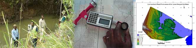
As associate consultant on the study of the flood preparedness information and flood forecasting model for the Songwe Trans boundary river basin project in Tanzania and Malawi. The analysis included heavy application of GIS to analyse, and map flooded zone, social and agricultural activities, analysis of weather information (rainfall data, discharge data, sedimentation, water quality etc) in order to identify the flood window and the flood occurrence frequency, identification of possible water supply infrastructure, identification of agricultural practice which leads to sediment into the river and the mitigations measures, development of flood preparedness indicators, Training of community members on indicators of floods in the study area, integrated water resource management, and on how to communicate the floods. |
WWF, Tanzania and Malawi |
February 2006 – May 2007 |
|
Tanzania Local Government Road Inventory and Condition Survey Project. This was a country wide road inventory and condition survey which involved mapping of the entire road network. The WEMA professional participated in the preparation of maps using the ARC GIS 9.0. Over 400 road maps were prepared including the country map, regional maps, and district maps. |
World Bank through Prime Minister’s Office Local Government, Tanzania |
April 2007 |
|
Rural Access Planning for the District Road Support Programme (DRSP) of Swiss Agency for Development and Cooperation (SDC). The major task was to develop a GIS database with major target of minimizing access time to market, water points, health centers, schools etc through improvement of road network in the district. This project aimed at making sure that all the key human needs are easily accessed. |
ZANCON (T) Ltd, Tanzania |
Oct 2003 |
|
Sub-consultant for the Transport/planning project for the government of Zanzibar financed by the World Bank. The project had three major tasks, to develop GIS maps of Zanzibar with all road network, prepare a transport planning concept of Zanzibar using a GIS software showing how the human services e.g. market, roads and harbour, transport means are in proportional with the ever increasing population and also to develop a policy paper with critical analysis of what transport policy and planning is required in Zanzibar. |
Government of Zanzibar |
March 2003 |